01Guilin is an internati…
Guilin is an international tourist city famed as having "the best landscape under heaven," and also a national historical and cultural city of deep roots; the Li River winds through it, green peaks rise layer upon layer along its banks and reflect in the water, so that the city lies within scenery and the scenery within the city, mountain, river and town together forming a natural great tray-landscape. The city lies in the northeast of Guangxi, covers 27,800 square kilometers in total, administers six districts and ten counties while overseeing one county-level city, and had a permanent resident population of 4.9384 million at the end of 2024. It has 2,133 years of city history and was among the first batch of national historical and cultural cities announced by the State Council in 1982. Guilin's sights can broadly be read on three levels: first, the rivers, where the Li River flows from north to south and the Yangdi to Xingping reach is the most celebrated stretch, hiding the Nine-Painted Mountain and the Yellow Cloth Reflection; second, the peak forests, caves and rocks, where Elephant Trunk Hill, Solitary Beauty Peak, Folded Brocade Hill and Reed Flute Cave each take a different shape; third, the fields and villages, where the Yulong River at Yangshuo and the Longji Rice Terraces at Longsheng turn landscape into a way of life. Beyond its mountains and water, Guilin has solid historical depth: the Lingqu Canal cut in the Qin dynasty linked the Xiang and Li rivers, layers of cliff inscriptions accumulated within the city, and the years of the War of Resistance left behind a name as a "cultural city." A subtropical monsoon climate keeps flowers blooming year-round, with misty rain in spring and clear skies in autumn — no matter when you come, you will not return empty-handed. Guilin is also a city where many peoples live together; Han, Zhuang people, Miao, Yao people, Dong and others have dwelled side by side for generations, and ordinary flavors such as rice noodles, Three-Flower wine and luo han guo share the table with the world-famous landscape, shaping the slow everyday rhythm of the city.
Guilin lies in the northeast of Guangxi, bordered to the north by Hunan, and is a city embraced by peak forest. The much-quoted saying that "Guilin's landscape is the best under heaven" first appeared in a verse composed on the spot at a banquet in 1201 by Wang Zhenggong, a Southern Song official; in the more than eight hundred years since, this line has almost become a byname of Guilin itself. It is an international tourist city famed as having the best landscape under heaven, a national historical and cultural city of deep roots, and an ecological landscape city fit to live in and to linger in. The Li River flows north to south past the city; within the urban area mountain, water and town interweave, so that green peaks meet the eye between the lanes and a few steps will bring you back to the water. The city is not large, yet it deserves a slower pace — two or three days walking along three threads of river, mountain and field will let you read it layer by layer.
Guilin's history can be traced remarkably far back. Cave sites such as Baojiyan and Zhenpiyan in the urban area show that human ancestors were active here as long as roughly ten thousand years ago; in the Xia, Shang and Zhou periods this was the homeland of the Baiyue peoples. In 214 BC the First Emperor of Qin ordered the Lingqu Canal to be cut, linking the Xiang and Li rivers and making Guilin the strategic hinge "linking the southern seas in the south and the Central Plains in the north"; the name "Guilin" itself dates from the Guilin commandery established in the Qin, so called because cassia (gui) grew in profusion here. In the sixth year of the Yuanding era of the Western Han (111 BC) Shian County was set up at present-day Guilin; in the first year of the Ganlu era of the state of Wu in the Three Kingdoms period (265 AD) the Shian commandery was established, with both commandery seat and county seat at present-day Guilin. In the fourth year of the Wude era of the Tang (621 AD) Li Jing built a city wall south of Solitary Beauty Peak; in the eighth year of the Zhenguan era (634 AD) it was renamed Lingui County; under the Song it belonged to Guizhou the prefecture in the Guangnan-Western Circuit Bridge, later to the Jingjiang Prefecture, under the Yuan to Jingjiang Route, and under both the Ming and Qing it served as the seat of Guilin Prefecture of Guangxi.
Under the Yuan Guilin belonged to Jingjiang Route of the Guangxi Xing Secretariat, and under both the Ming and Qing it served as the seat of Guilin Prefecture of Guangxi, remaining for long stretches the political and cultural center of the whole province. In the Ming the Jingjiang Prince's Mansion was built within the city, and its walls still stand in the center of town today. Guilin City was first set up in 1940; during the War of Resistance against Japanese Aggression, large numbers of cultural figures gathered here and Guilin for a time served as the "cultural city" of the rear area. In 1982 Guilin was included in the first batch of national historical and cultural cities announced by the State Council, and now has 2,133 years of city history; in 1998 the old Guilin City and the old Guilin Prefecture merged to form the new Guilin City, in 2013 Lingui County was abolished and Lingui District established in its place, and in 2018 Lipu County was abolished and the county-level Lipu City established in its place, forming the layout Guilin still has today.
02Guilin lies in the nor…
Guilin lies in the northeast of Guangxi, at the southern end of the Xiang-Gui corridor and the southwestern part of the Nanling mountain system; to the north and northeast it borders Hunan, to the southeast it adjoins Hezhou, to the south it neighbors Wuzhou and Laibin, and to the west it joins Liuzhou. The whole municipality covers 27,800 square kilometers, accounting for 11.74% of Guangxi's total area, and stretches 236 kilometers north to south and 189 kilometers east to west. The landforms are dominated by karst, where peak forests and peak clusters appear side by side: peak forests stand separated by flat ground, while peak clusters are joined at their rocky bases, and the banks of the Li River offer the representative text of peak clusters. In 2014, Guilin karst was inscribed on the World Natural Heritage list as part of the second phase of South China Karst, joining Yunnan's Stone Forest, Guizhou's Libo and Chongqing's Wulong to form this serial heritage. Guilin's karst landforms are well-developed and typical, and the city has long been regarded as a natural classroom for the study of karst.
The whole of Guilin administers six districts, ten counties and autonomous counties, and oversees one county-level city: the urban districts are Xiufeng, Diecai, Xiangshan, Qixing, Yanshan and Lingui, the counties and autonomous counties include Yangshuo, Lingchuan, Quanzhou, Xing'an, Yongfu, Guanyang, Longsheng, Ziyuan, Pingle and Gongcheng, and the county-level city is Lipu. Below the districts and counties stand 13 sub-district offices, 88 towns and 46 townships, of which 15 are ethnic townships. At the end of 2024 the municipality's permanent resident population stood at 4.9384 million. Guilin is also a city where many peoples live together, with Han, Zhuang, Miao, Yao, Dong, Hui, Gin, Yi, Shui, Manchu and others dwelling side by side for generations; Longsheng and Gongcheng, the two autonomous counties, are especially noted for their ethnic character.
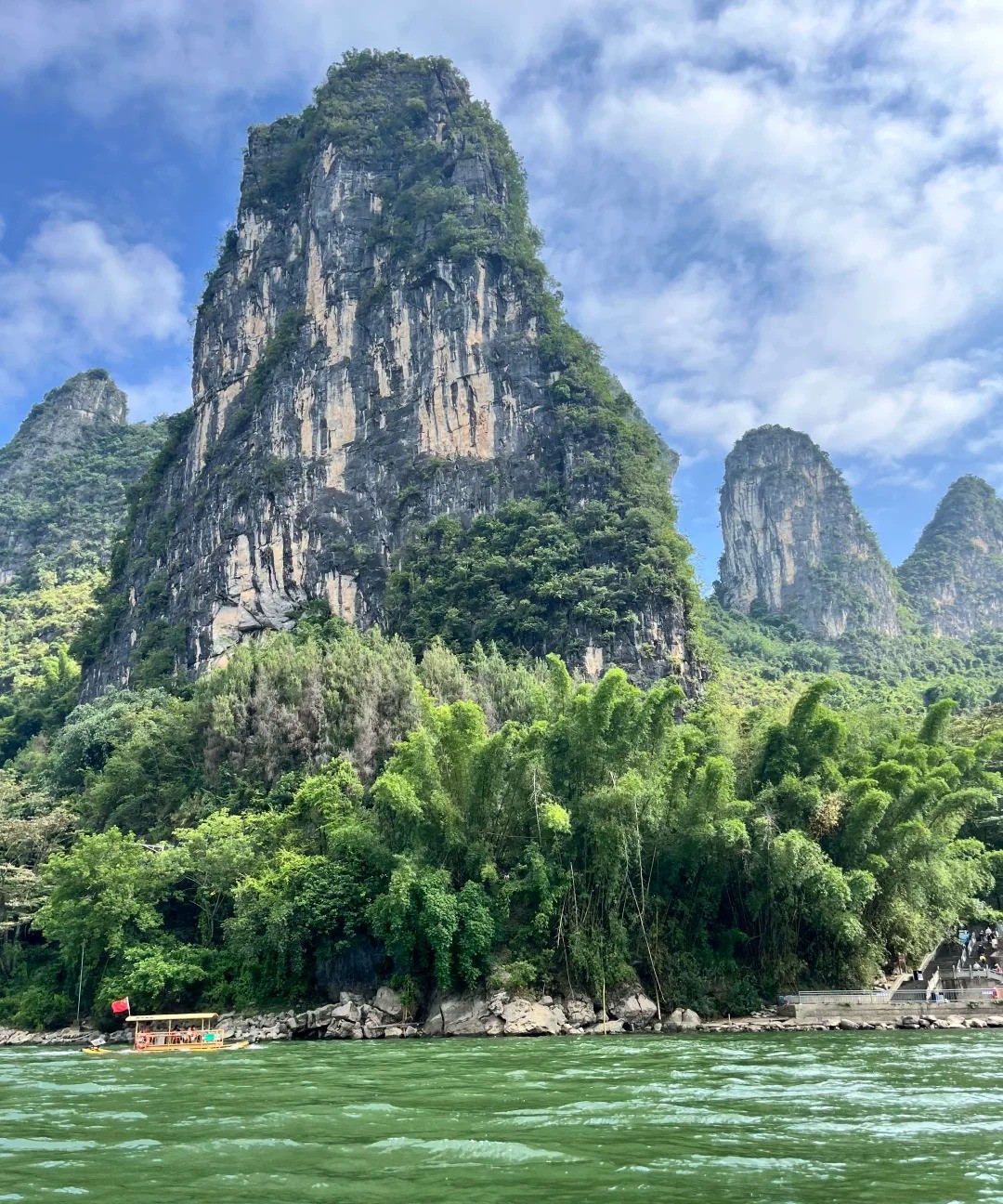
For most people, the name Guilin is the Li River. The Li River belongs to the upper reach known as the Guijiang within the Pearl River system; it is 214 kilometers long in total, with a main stream of 164 kilometers, of which 100 kilometers flow through the Li River Scenic Area. This scenic area was among the first batch of national scenic areas approved and announced by the State Council, with a total area of 1,159.4 square kilometers and a core area of 303.2 square kilometers, accounting for about 26.1% of the scenic area's total area; it is composed of eight sub-areas: Guilin city proper, Caoping, Yangdi, Xingping, Pubutang, Yangshuo, Putao and Lingqu. Boats can navigate the river year-round; visitors drifting downstream by boat or bamboo raft watch green peaks unroll in succession on either bank, the water clear and blue-green, the peaks gathering and scattering in the ripple — "the river like a sash of black silk, the mountain like a hairpin of jade" is the image such a sight calls to mind.
The most celebrated stretch of the Li River runs between Yangdi and Xingping. As boats reach this reach the river broadens and the green peaks roll on in unbroken succession, and visitors raise them cameras again and again. The Nine-Painted Mountain is a tall cliff face that stands by the river, its mottled coloration so arranged that, by tradition, one can pick out the forms of galloping horses in it, and how many you can see is entirely a matter of your own eyes — over time this has become a familiar tale on the river. A short distance further on is the Yellow Cloth Reflection, where the current is slow and the water lies mirror-flat, so that the green hills and the sky are reflected together in the river; this is the most classic image of Li River scenery. Not far from the riverbank stands the old town of Xingping, its old houses lining the river and its flagstone paths stretching along the bend, the layout of an old wharf still to be seen in town.
03Drifting further south…
Drifting further south on the river you enter Yangshuo County. Yangshuo County covers a land area of 1,435.62 square kilometers, administers the six towns of Yangshuo, Baisha, Xingping, Fuli, Gaotian and Putao, together with the three townships of Jinbao, Yangdi and Puyi, and at the end of 2024 had a registered population of 325,900. Apart from the Li River, the other river that lingers in the memory at Yangshuo is the Yulong River: it is slower and quieter than the Li River, with fields of rice and bamboo lining its banks; drifting downstream on a bamboo raft, you sometimes meet a small dam where the water drops and the spray flies, drawing a small cry from the raft. Not far from the county seat stretches the Ten-Mile Gallery, a roadside scenic belt where scenes such as Moon Hill unroll in succession; the most pleasant way to take it is by bicycle, at your own pace. By night West Street is ablaze with music and light, the liveliest spot in Yangshuo, where many languages cross one another and a special atmosphere takes shape on its own.
Back in Guilin's urban area, the first sight to see is Elephant Trunk Hill. It rises at the confluence of the Li River and the Peach Blossom River, its shape uncannily like an elephant drinking from the river; in 1995 it was made the city emblem of Guilin. Today Elephant Hill is joined with the Two Rivers and Four Lakes into a single unit and forms part of a national 5A-level tourist attraction. The Two Rivers and Four Lakes refers to the Li River, the Peach Blossom River and the four lakes of Rong, Shan, Gui and Mulong; these waters are the remains of the moats of the Song, which, after urban renewal, now encircle the old city, their edges shaded by trees and the bridges' reflections joining the reflections on the water. By day one can stroll along the lakes and watch the peaks' reflections fall into the water; by night the lights come on and the shadows of bridges and pagodas are reflected together in the lake, a tour boat gliding slowly across.
At the heart of the city, Solitary Beauty Peak and the Jingjiang Prince's Mansion together form a scenic area, also a national 5A-level tourist attraction. Solitary Beauty Peak rises sheer from flat ground, standing alone in solitary beauty, and has been one of the landmarks of Guilin's urban area since antiquity; the Ming-dynasty Jingjiang Prince's Mansion was built against the peak, and its walls still enclose this quarter of the city today. On the cliffs below the peak and around the city a great number of inscriptions of successive periods survive, the cliff inscriptions of Guilin numbering nearly 2,500 pieces in total, with the Guihai Forest of Steles specially built within the city to house and display stone tablets. These inscriptions, accumulating one on top of another, are a layer of solid weight behind Guilin's mountains and water. In the nearby Dongxixiang alleys and Old South Gate area, the old houses and the flagstone paths still hold the old city's atmosphere; walking there at dusk you best see the everyday character of this town.
Guilin's mountains hold many caves, and the local saying is "no mountain without caves, and every cave is strange and quiet." The earlier-developed caves include Seven Star Cave, Reed Flute Cave, White Dragon Cave and Chuan Mountain Cave. Reed Flute Cave lies in the northwestern suburbs, where stalactites, stalagmites, stone columns and stone curtains stack layer upon layer, taking on strange shapes in the lighting; it is one of Guilin's representative caves. Seven Star Cave lies within Seven Star Park, its passages twisting and its corridors deep. Outside the city, Crown Cave opens by the river and contains an underground river that can be navigated by boat. Guilin's caves are sometimes as broad as a public square, sometimes twisting and deep, with stalactites and stone curtains that, in light and dark, resemble melons or fruit, golden grain or a whole human realm; it is all up to each visitor's imagination.
04North out of Guilin's …
North out of Guilin's urban area lies Xing'an County, with the Lingqu Canal cut in the Qin dynasty right beside the county seat. The Lingqu Canal was cut on the orders of the First Emperor of Qin to unify Lingnan by Shi Lu; it links the Xiang and Li rivers, joining the Yangtze and Pearl River systems, is 37 kilometers long in total, and still irrigates about 65,000 mu of good farmland today. It is hailed as a pearl of ancient world water architecture and, together with Zhengguo Canal in Shaanxi and Dujiangyan in Sichuan, is known as one of the three great waterworks of ancient China. The canal head uses a plow-shaped diversion dyke together with the Greater and Lesser Tiansheng the water dividers to divide the waters of the Xiang River in two — three tenths flowing south to the Li River and seven tenths flowing back north to the Xiang — and the steep gates (dou men) set within it to raise the water level so that boats can be hauled up step by step are regarded as the earliest water-gate buildings. In 1988 the Lingqu Canal was announced as a national key cultural relics protection unit; in 2006 it was rated a national 4A-level tourist attraction; and in 2018 it was inscribed on the World Heritage Irrigation Structures list.
In the northwest of Guilin, Longsheng Various Nationalities Autonomous County holds the Longji Rice Terraces, a stretch of terraces built up against the mountains. The terraces are distributed between 300 and 1,100 meters above sea level, with maximum gradients of up to 50 degrees, winding layer upon layer from the foot of the mountain to the summit in sweeping lines of great breadth and force. The Longji Rice Terraces divide into the Yao-people terrace scenic area of Jinkeng Dazhai and the Zhuang-people terrace scenic area of Ping'an; the two most celebrated scenes at Ping'an Village are the "Nine Dragons and Five Tigers" and the "Seven Stars Accompanying the Moon": nine small ridges and five small hills are all wrapped in terraces, while seven small mounds are scattered between the fields, so that from afar they look like seven stars standing watch over a crescent-moon-shaped field at the center. The terraces of Longsheng have been cultivated for more than 2,300 years; in 2018 Longsheng's Longji Rice Terraces were inscribed on the Globally Important Agricultural Heritage Systems list as part of China's Southern Mountain Rice Terraces System. The scenic area lies 77 kilometers from Guilin's urban area, with mountain roads winding up; the season when water has just been let in and the season when the rice is ripe are when the views are at their best.
Longsheng is one of only two various-nationalities autonomous counties in the country, and was one of the first batch of minority autonomous areas the country established. The whole county covers an area of 2,538 square kilometers, with a total population of 170,000, of whom minorities make up more than 80%; Miao, Yao, Dong, Zhuang and Han peoples have lived side by side for generations, and forest coverage reaches 82.55%. Here the terraced fields cover 200,300 mu in total, with the most layered stretch rising through more than 1,100 tiers — however high the mountain, the fields rise as high. The villages are mostly of stilted wooden houses, with the shapes of those working in the fields now and then visible on the ridges; Longji tea, chili, water-wine and glutinous rice are known as the Four Treasures of Longji. Walking through a village you will often hear mountain songs, and you may come across a lively ethnic festival.
Guilin's terrain is high around the edges and low in the middle, and on the Yuecheng Ridge to the north stands Mao'er Mountain, the tallest peak in South China and the source of the three rivers (Sanjiang) — the Zi, the Li and the Xun — which share their headwaters yet flow in different directions, forming one remarkable sight. The Mao'er Mountain area, with its dense vegetation, is an important nature reserve of the city and a summer retreat. Guilin lies in the Nanling mountain area and is a priority area for biodiversity conservation in China; the city is home to a wide variety of vascular plants, with Cathaya argyrophylla, Ziyuan fir and southern Chinese yew ranked as national first-class protected plants, while among wild animals the yellow-bellied tragopan, golden eagle, leopard and clouded leopard are national key protected species. Large stretches of greenery are kept between city and landscape, and that is also the basis of Guilin's character as "the city within scenery, the scenery within the city."
05On your first day in G…
On your first day in Guilin, the first bowl is always reserved for rice noodles. Guilin people take rice noodles for breakfast, and also as a late-night snack; a bowl of hot blanched rice noodles is dressed with braised sauce and a few toppings and eaten dry, with more broth added halfway, the most down-to-earth way to eat them, the small shops in the ordinary lanes always full of locals year-round. The Three Treasures of Guilin refer to Three-Flower wine, chili sauce and fermented tofu. If you come to Yangshuo, the Yangshuo beer fish is not to be missed — the fish flesh is tender and the broth is rich; Lipu taro is powdery and glutinous, and steamed with pork it shows its quality best, the taro absorbing the juices of the meat and melting on the tongue. The night markets and old streets in the city come alive at night, the aroma of rice noodles mingling with sour and piquant flavors, and the city's everyday warmth spreads out just like this.
Guilin's local products bear the mark of mountains and water. Sweet osmanthus is the city flower of Guilin, so designated in 1984 by a resolution of the municipal People's Congress; in autumn its fragrance drifts through the lanes and streets — "Guilin, Guilin, cassia groves make a forest" — and the city's name and the sweet osmanthus have always been hard to separate. The pomelos of Shatianping are large and beautifully shaped, with a fragrant aroma in the flesh; luo han guo is hailed as the "Eastern divine fruit"; ginkgo accounts for one third of the national output; and there are also summer oranges, moon persimmons, water chestnuts, rice-field fish, tofu skin and other local products. The waters of the Li River grow fat fish and shrimp, and the bamboo shoots and mushrooms of the mountains are in season the year-round — these local products are everyday flavors on the tables of locals.
Guilin has a subtropical monsoon climate, with mild temperatures, abundant rainfall, a long frost-free period and four distinct seasons, with long summers and short winters and rain and heat sharing the same seasons. Using the 1981–2010 normals, the mean annual temperature stands near 19.1°C; July and August are the warmest months, averaging around 28°C; January and February are the coldest, averaging around 9°C. The mean annual rainfall reaches 1,887.6mm, with 166 mean annual precipitation days, the relative humidity about 76%, and sunshine hours about 1,447.1; wind is light, mainly from the north. Guilin has "little snow in three winters and flowers in every season," and Du Fu long ago wrote of the place: "of the Five Ridges all are hot, but of all fit for man, Guilin stands alone." Spring brings a misty rain, the river turning green-blue and the peaks half-hidden in the fog; autumn is the most comfortable season, with a high sky and light clouds, the right time for looking at mountains and water.
Guilin is a national comprehensive transportation hub, where the Heng-Liui railway, the Gui-Guang Railway and the Xiang-Gui railway meet, with a total rail operation mileage of 690 kilometers, of which 420 kilometers are high-speed; Guilin has nine stations, including Guilin Station, Guilin North Station, Guilin West Station, Yangshuo Station and Gongcheng Station. On the air side, Guilin Liangjiang International Airport is located at Liangjiang Town in Lingui District, about 28 kilometers from the city center; it began operations in 1996 and opened its new terminal in 2018, with flights to and from major cities at home and abroad. On the road side, national highways and a number of expressways link the surrounding areas, and every county in the city has expressway access; on the water side, channels such as the Li River and the Guijiang run through, and traveling up the Li River is itself the most classic journey in Guilin. Within the municipality, Yangshuo, Longsheng and other directions are all reachable by road, and getting around is no trouble.
06The most comfortable w…
The most comfortable way to lay out three or four days in Guilin is to keep the first day in the city — Elephant Trunk Hill and the Two Rivers and Four Lakes in the morning, Solitary Beauty Peak, the Jingjiang Prince's Mansion and the Guihai Forest of Steles in the afternoon, with dinner in the Dongxixiang area at evening. The second day is given to the Li River — leaving the city by boat or bamboo raft and drifting downstream, taking in the Nine-Painted Mountain and the Yellow Cloth Reflection along the river, and reaching the old town of Xingping in the afternoon before going on to Yangshuo county town to spend the night. The third day is for cycling the Ten-Mile Gallery and drifting the Yulong River at Yangshuo, with a stroll down West Street by night. If a fourth day is available, head north to Xing'an to see the Lingqu Canal, or west to Longsheng to see the Longji Rice Terraces — for the latter the road winds through the mountains, so it is best to set aside a whole day and stay a night by the terraces; the sea of clouds at dawn is worth the wait.
The best of Guilin lies not in any one sight but in the way the city keeps company with its mountains and water: the river flows through the city, the peaks stand outside the window, and people walk as if within a painting. It bears being looked at closely, and it bears being treated slowly. Whether drifting on an on the Li River for a morning, waiting for a sunrise on a ridge of a Longji terrace, or sitting in a noodle shop watching a local mix a bowl of rice noodles with practiced ease, you will understand that the line "Guilin's landscape is the best under heaven" has never been only about mountains and water — it has also been about the way people live out their days within such a landscape. Lay out your plans loosely, and Guilin will, bit by bit, return its kindness to you.